| |

|
|
|
| |
 East Hoathly in East Sussex was on the main A22 Uckfield to Eastbourne road near Halland
until bypassed in 1992 which has now made it a nicer quieter place to live,
work and shop.
In the village lived the Sussex Cannibal, Colonel Sir Thomas Lundsford who
was said to dine on children, and carry their limbs in his pocket for snacks. East Hoathly in East Sussex was on the main A22 Uckfield to Eastbourne road near Halland
until bypassed in 1992 which has now made it a nicer quieter place to live,
work and shop.
In the village lived the Sussex Cannibal, Colonel Sir Thomas Lundsford who
was said to dine on children, and carry their limbs in his pocket for snacks.
This may have been a smugglers tale ( also see Brede ) designed to scare the
general public, or from his reputation in battle. He was charged in 1632 for
killing deer in the estate of Sir Thomas Pelham at Halland Place. He tried to
kill Sir Thomas at the church, but was fined, and in 1649 sold eveything and
emigrated to Virginia.
Thomas Turner (1729 - 1789) lived in East Hoathly and he kept a very
comprehensive diary covering eleven years of his life. As he was shopkeeper,
churchwarden, Overseer of the Poor and much more, he has a great deal to say
about the every day happenings of this small agricultural village.
At the time of his writings nearby Halland House was in existence. It was one
of the mansions owned by the influential Pelham family (see also Laughton and
Halland ) and their emblem, the Pelham Buckle, can be found over the West door
of the church together with the Boars heads which represent the arms of the
Lunsford family who lived at Whyly.
The area was in the iron industry as it is close to the Waldron and Heathfield
furnaces the results are visible as there are iron milestones in the area with
the Pelham Buckle on them.
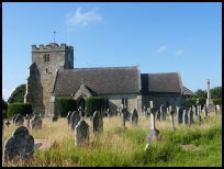
East Hoathly church was rebuilt, with the exception of the tower which is
fifteenth century perpendicular, in 1855. During the rebuilding a Norman
pillar piscina was found in the foundations, and can now be seen near the
altar. There are very fine mosaics above the altar. There are also several
very good stained glass windows.
East Hoathly churchyard contains two gravestones with plaques by
Jonathan Harmer from nearby Heathfield one lies to the east of the porch
and the other near the south east corner of the Chancel. There is also a
modern imitation on a gravestone in the new burial ground.
East Hoathly was also one of the villages with a trug making business
Rich Trugmakers . Unfortunately their records were destroyed in a fire,
so it is a matter of some dispute as to who were the first trugmakers in
Sussex Thomas Smith of Herstmonceux or Rich of East Hoathly .
(We are very greatful to Jane Seabrook for providing much of the local
information available on this page and on the Halland page.) |
|
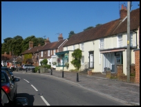
 The centre of the village is very attractive and is a conservation area,
this used to be on the busy A22 until 1992, and has a 90 degree bend
which must have been difficult for large lorries to manouver round. The centre of the village is very attractive and is a conservation area,
this used to be on the busy A22 until 1992, and has a 90 degree bend
which must have been difficult for large lorries to manouver round.
The Weald Way runs through the village providing quiet walks throughout
the surrounding countryside. |
|
 The village has a large number of shops and local amenities with a Primary
School, Public Houses and Gift shop. The village has a large number of shops and local amenities with a Primary
School, Public Houses and Gift shop.
The nearest shopping centre is at nearby Uckfield about 6 miles to the north.
Trains can also be caught from the station at Uckfield .
The nearest major shopping centre is at Lewes about 6 miles south east. |
|
| East Hoathly is shown as the red symbol on the map. |
|
|
Nearby Villages
(click on symbol to see the village page) |
| Village= | |
Town= | |
Recorded in Domesday= |  |
| |
|
|
Barcombe |
(Village in three places) | | 6.49 miles |
|
|
Blackboys |
(Charcoal and Soot) | | 2.48 miles |
|
|
Broad Oak |
(Smallpox at the Academy) | | 6.41 miles |
|
|
Cade Street |
(Jack Cade and the Kentish rebellion) | | 5.91 miles |
|
|
Chiddingly |
(Walking on Cheese ??) | | 1.84 miles |
|
|
Cross in Hand |
(The Crusaders Assembly) | | 4.17 miles |
|
|
Framfield |
(380 years without a church tower) | | 3.14 miles |
|
|
Halland |
(Ancient Slaughter) | | 1.33 miles |
|
|
Heathfield |
(19th Century Natural Gas) | | 4.89 miles |
|
|
Hellingly |
(Only remaining Ciric in Sussex) | | 4.40 miles |
|
|
Horam |
(Which Station do we get off at ?) | | 3.44 miles |
|
|
Isfield |
(Simon de Montfort and the Lavender Line) | | 4.45 miles |
|
|
Laughton |
(Knight captures King of France) | | 2.34 miles |
|
|
Newick |
(Killer Cricket and Dirk Bogarde) | | 7.44 miles |
|
|
Piltdown |
(The Piltdown Man hoax) | | 6.03 miles |
|
|
Punnetts Town |
(The Windmill on the Hill) | | 7.17 miles |
|
|
Ringmer |
(Poor Roads and riots) | | 5.38 miles |
|
|
Ripe |
(Earl Harolds estate) | | 3.96 miles |
|
|
Rushlake Green |
(Open Village and Nuclear Bunker) | | 6.65 miles |
|
|
Uckfield |
(Traction Engine destroys bridge) | | 4.15 miles |
|
|
Vines Cross |
(Cannons and Doodlebugs) | | 4.49 miles |
|
|
Waldron |
(Fullers Earth) | | 2.50 miles |
|
|
Warbleton |
(The Iron Man) | | 5.47 miles |
|
|
| Copyright Villagenet 1998-2025 | |
| |
|
|
Local Interest
Just click an image |
|
|
|
|
|
|
|
|
|
|
|
|
|
|
| |