| |

|
|
|
| |
 Hamsey in East Sussex lies on an island in the middle of the Ouse valley, but
during the period of the Black Death the island was abandoned
and the population moved across the valley to the south west
to Offham which is just on the edge of the downs. Hamsey in East Sussex lies on an island in the middle of the Ouse valley, but
during the period of the Black Death the island was abandoned
and the population moved across the valley to the south west
to Offham which is just on the edge of the downs.
The island was a major Saxon town and port, where at least once
during his reign King Ethelstan (925-940) held his court . It
would seem likely that the river was navigable up to Hamsey, and
that the small island would have been a fortified area surrounded
by fresh water, fish and fertile farmland.
The village remained in the valley until 1348 when the Black Death
forced the inhabitants to move away from the church as did a
number of other villages in the area. The island remained abandoned
or very sparsely populated until this day, the only remaining
resident is the church. |
|
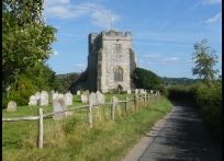
 The old church at Hamsey in East Sussex is found by travelling down a narrow
track across the Ouse valley, then up a small but steep hill
to the church. The view from the church is very pretty, with
the valley all round it has the feel of ancient centuries. The old church at Hamsey in East Sussex is found by travelling down a narrow
track across the Ouse valley, then up a small but steep hill
to the church. The view from the church is very pretty, with
the valley all round it has the feel of ancient centuries.
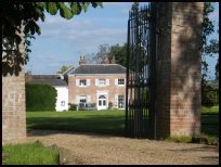
Hamsey Manor is across the valley from the church but is very
attractive. |
|
 Hamsey in East Sussex has no services, but Offham on the main Lewes to East
Grinstead road has a few. Hamsey in East Sussex has no services, but Offham on the main Lewes to East
Grinstead road has a few.
The nearest trains run from Lewes about 3 miles to the south,
and this is where the nearest major shopping centre is.
The church has a few services - May - Sept - Sunday Evensong, and at Christmas a very popular Nine Lessons and Carols. It is a functioning church with a graveyard which is still open. |
|
| Hamsey is shown as the red symbol on the map. |
|
|
Nearby Villages
(click on symbol to see the village page) |
| Village= | |
Town= | |
Recorded in Domesday= |  |
| |
|
|
Barcombe |
(Village in three places) | | 1.50 miles |
|
|
Beddingham |
(At the base of Mount Caburn) | | 3.71 miles |
|
|
Glynde |
(Home of English Opera) | | 3.84 miles |
|
|
Halland |
(Ancient Slaughter) | | 6.41 miles |
|
|
Isfield |
(Simon de Montfort and the Lavender Line) | | 3.93 miles |
|
|
Laughton |
(Knight captures King of France) | | 5.93 miles |
|
|
Ringmer |
(Poor Roads and riots) | | 2.43 miles |
|
|
Ripe |
(Earl Harolds estate) | | 6.56 miles |
|
|
Selmeston |
(Tomb to store the Contraband) | | 7.33 miles |
|
|
Firle |
(Home of the Greengage) | | 5.21 miles |
|
|
| Copyright Villagenet 1998-2025 | |
| |
|
|
Local Interest
Just click an image |
|
|
|
|
|
|
|
|
|
|
|
|
|
|
| |