| |

|
|
|
| |
 East Guldeford in East Sussex is located on the A259 about 2 miles from the
small town of Rye . East Guldeford in East Sussex is located on the A259 about 2 miles from the
small town of Rye .
 Before the 15th century, the area was mostly salt marshes
, and had a thriving salt manufacturing industry, by
drying shallow sea water pools.
The village consists of the church and a few house, and
was built on land reclaimed from the sea by Sir Richard
Guldeford, who built a sea wall, and drained the salt water
to provide rich farmland during the late 1400's.
In 1512 the harbour at Rye was looked on as important by Sir Richard who built
the small defensive fort of Camber Castle. This was expanded by Henry VIII to
provide cover to the harbour in the Camber(Chambre) between present Camber ,
East Guldeford , Rye and Winchelsea. The fort became obsolete by 1637 as the
Camber had silted so badly.
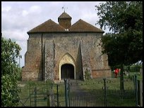
At first glance the church, situated on a bleak out-post on Guldeford
(pronounced Gilford) Levels, resembles a barn more than a
church! It is situated in a field, and is brick built. It was
built under the auspices of Sir Richard Guldeford in 1505.
The church has a very unusual twin roof design with the bell cote
balanced between the two roofs.
The inside is a simple hall with a plastered ceiling. Much
restoration was carried out in Victorian times. There is an
unusual freize of seraphim and musical instruments. The bowl
of the font has rosettes on, and dates from the 12th century,
implying a relocation from another church, possibly from France.
St Mary at East Guldeford is one of those churches supported by the
Romney Marsh Historic Churches Trust . |
|
 East Guldeford in East Sussex is another of the isolated communities on the Marshes,
but has magnificent views across the flat marshland all round. East Guldeford in East Sussex is another of the isolated communities on the Marshes,
but has magnificent views across the flat marshland all round.
In the morning look to the west and see the town of Rye on its 'island'.
In the evening again look to the west to see the sun setting behind Rye
and the Firehills. |
|
 East Guldeford in East Sussex has no shops or services, the main
shopping town is Rye about 2 miles to the West. East Guldeford in East Sussex has no shops or services, the main
shopping town is Rye about 2 miles to the West.
The nearest train service runs across the Romney Marsh ,
stopping at nearby Rye station about 2 miles from the
village. |
|
| East Guldeford is shown as the red symbol on the map. |
|
|
Nearby Villages
(click on symbol to see the village page) |
| Village= | |
Town= | |
Recorded in Domesday= |  |
| |
|
|
Beckley |
(Alfred the Great and Guns !) | | 5.40 miles |
|
|
Brenzett |
(St Eanswyth a saxon princess) | | 5.58 miles |
|
|
Brookland |
(13th century wooden spire) | | 4.48 miles |
|
|
Broomhill |
(Swept away by the Storm) | | 3.21 miles |
|
|
Camber |
(Sands and Holidays) | | 2.34 miles |
|
|
Fairfield |
(The Isolated Church) | | 3.71 miles |
|
|
Guestling |
(Changing guards at Buckingham Palace) | | 6.71 miles |
|
|
Icklesham |
(Paul McCartney's Recording Studio) | | 4.66 miles |
|
|
Iden |
(Sheriff of Kent and Jack Cade) | | 1.97 miles |
|
|
Ivychurch |
(The burial ground on the Island) | | 6.92 miles |
|
|
Lydd |
(The Cathedral of the Marsh) | | 6.65 miles |
|
|
Newenden |
(Alfred the Great's Fort) | | 7.31 miles |
|
|
Old Romney |
(Sheep and Wool Smuggling) | | 6.51 miles |
|
|
Old Winchelsea |
(Abandoned after the Great Storm) | | 2.75 miles |
|
|
Peasmarsh |
(Black Death moves village) | | 3.63 miles |
|
|
Playden |
(Saltcote and fish) | | 1.04 miles |
|
|
Rye |
(On the Island) | | 1.02 miles |
|
|
Rye Harbour |
(Nature Reserve and unspoilt beaches) | | 1.48 miles |
|
|
Udimore |
(Angels move the Church) | | 4.76 miles |
|
|
Winchelsea |
(Inland Cinque Port !!) | | 3.10 miles |
|
|
Winchelsea Beach |
(Holidaymakers and Henry VIIIs Fort) | | 3.28 miles |
|
|
Wittersham |
(Park your Airship here ?) | | 4.26 miles |
|
|
| Copyright Villagenet 1998-2025 | |
| |
|
|
Local Interest
Just click an image |
|
|
|
|
|
|
|
|
|
|
|
|
|
|
| |