| |

|
|
|
| |
 Hadlow in Kent lies on the A26 between Tonbridge and Mereworth in the
Vale of Kent, the Medway valley . The old name for the settlement
is Haeselholte, a Saxon word which is found in the Textus Roffensis
and then Haslow in the Domesday Book , the middle ages it became
Hadloe now Hadlow. Hadlow in Kent lies on the A26 between Tonbridge and Mereworth in the
Vale of Kent, the Medway valley . The old name for the settlement
is Haeselholte, a Saxon word which is found in the Textus Roffensis
and then Haslow in the Domesday Book , the middle ages it became
Hadloe now Hadlow.
The Romans are believed to have settled here as coins and
pottery have been found in the village.
In 1018 the village was granted to Queen Eddeva the consort
of Edward the Confessor. After 1066 the land was given to
Richard de Clare, who in turn granted it the
Knights Hospitallers of St John of Jerusalem in 1166 who
were based at nearby West Peckham. The Knights held the land
until Henry VIII dissolved the order and the Monasteries in
1536 - 37 .
The Fane family bought the land from Henry VII and built
Hadlow Place. They in turn sold it to the May family in
1647. The most famous family member was Walter Barton May,
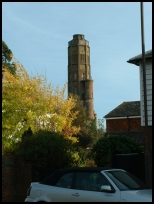
an industrialist from the late 1800's who created Hadlow
'Castle' a late Victorian Gothic home, with a tower now
known as Hadlow Tower or May's Folly . It is said that the
tower 170ft tall was built to allow May to view the Channel,
however the channel cannot be seen from here.
He also had a mausoleum built in the churchyard where he
was to be buried sitting up above the ground, but he was
buried in a normal manner, and the mausoleum remained empty.
The area has been one of the centres of the hop growing industry,
and in 1858 the river Medway overflowed at Hadlow, and 30 hop
pickers were drowned when their cart fell off the bridge
into the flood water. The hops were turned into beer in the village,
as the remains of the old brewery shows , nowadays it has been
converted into luxury flats.
Mays folly fell into disrepair and was saved from demolishion
in 1951 by the painter Bernard Hailstone. It has recently
been repaired, but has lost much of its Gothic splendour as
the pinnacles have been removed for safety reasons. |
|
 Hadlow in Kent has Mays folly, which can be seen from many miles away,
together with the gothic entrance to Hadlow castle. Hadlow in Kent has Mays folly, which can be seen from many miles away,
together with the gothic entrance to Hadlow castle.
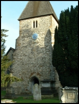
The church has a large number of very interesting hatchments
originating during the 18th and 19th centuries. |
|
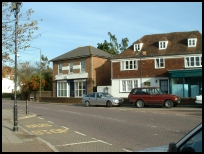
 The village is well served by local shops, and lies on the main
Maidtone to Tonbridge bus service. The village is well served by local shops, and lies on the main
Maidtone to Tonbridge bus service.
The nearest main shopping centre lies about 3 miles to the west
of Hadlow in Kent at Tonbridge, from where the main line London to Dover
railway service runs. |
|
| Hadlow is shown as the red symbol on the map. |
|
|
Nearby Villages
(click on symbol to see the village page) |
| Village= | |
Town= | |
Recorded in Domesday= |  |
| |
|
|
East Peckham |
(Centre of the Hop Industry) | | 2.35 miles |
|
|
Marden |
(Broadcloth and Agriculture) | | 7.60 miles |
|
|
Mereworth |
(The First Victoria Cross) | | 3.15 miles |
|
|
Paddock Wood |
(Railway brings prosperity) | | 3.62 miles |
|
|
Sevenoaks Weald |
(Lower the tower by twenty feet) | | 6.41 miles |
|
|
Tudeley and Capel |
(Iron Industry and Hop Pickers) | | 3.01 miles |
|
|
Yalding |
(longest medieval bridge in Kent) | | 4.14 miles |
|
|
| Copyright Villagenet 1998-2025 | |
| |
|
|
Local Interest
Just click an image |
|
|
|
|
|
|
|
|
|
|
|
|
|
|
| |