| |

|
|
|
| |
 Matfield in Kent lies on the B between Pembury and Paddock Wood ,
about 6 miles to the north east of Royal Tunbridge Wells off
the A21. Matfield in Kent lies on the B between Pembury and Paddock Wood ,
about 6 miles to the north east of Royal Tunbridge Wells off
the A21.
The village name is derived from the Anglo Saxon feld meaning
large clearing and from the farm run by Matta hence Mattafeld,
which is quite similar to the modern Matfield .
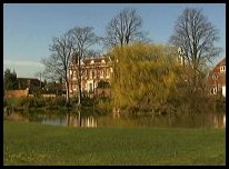
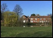
The village is made up of a mixture of old and modern houses
and sports one of the largest village greens in the county of
Kent. Around the green can be seen several tile hung Kentish
cottages, and an impressive Georgian Mansion.
After the Norman Conquest in 1066 , the land was given to Richard
FitzGilbert, the cousin of William the Conqueror .
The white weatherboard pub - The Wheelwrights Arms was built
in 1602, and was originally a farm building. The building was
converted into an ale house around 1750.
During the 1728 the house known as Matfield House , the
gorgeous mansion on Matfield green was built. It was built
by Thomas Bold Marchant a farmer from Horsmonden , and his wife
Mary who was a wealthy heiress from Marden .
The First World War poet Siegfried Sassoon was born in
Matfield .
During the Second World War, the village gained fame as the
scene of a triple murder, perpetrated at Crittenden cottage
just outside the village.
In 1997 the Parish hit international headlines when Badzel Park
Farm and Rural Centre became home to the 'Tamworth Two'. The
Two pigs that made a well publicised bid for freedom on their
way to the slaughterhouse. After finally being captured, they
were reprieved by public demand, and shipped to Matfield where
they are now two of Badzel Park's most famous residents. |
|
 Matfield in Kent has at its centre the beautiful village green and duck
pond. This green is surrounded by many beautiful old houses. Matfield in Kent has at its centre the beautiful village green and duck
pond. This green is surrounded by many beautiful old houses.
The village green hosts the cricket team, and the sound of
willow on leather on a hot summer afternoon, together with
the surroundings makes a relaxing scene. |
|
 Matfield in Kent has a number of small village shops providing
the usual village items. Matfield in Kent has a number of small village shops providing
the usual village items.
The nearest trains run from Paddock Wood about 3 miles to
the North, these link Ashford to London with a service aprox
every 30 minutes.
The nearest shopping centre is Royal Tunbridge Wells about
6 miles to the south west. |
|
| Matfield is shown as the red symbol on the map. |
|
|
Nearby Villages
(click on symbol to see the village page) |
| Village= | |
Town= | |
Recorded in Domesday= |  |
| |
|
|
Bells Yew Green |
(The ruins of Bayham Abbey) | | 4.40 miles |
|
|
Brenchley |
(A beautiful Kent village) | | 1.30 miles |
|
|
Eridge Green |
(The home of the Neville Family) | | 7.14 miles |
|
|
Frant |
(King Johns hunting lodge) | | 5.54 miles |
|
|
Goudhurst |
(Smugglers, Iron and Forests) | | 4.66 miles |
|
|
Horsmonden |
(The largest Wealden Iron Works) | | 2.83 miles |
|
|
Kilndown |
(Charcoal for the Furnace) | | 4.72 miles |
|
|
Lamberhurst |
(Scotney Castle and Gardens) | | 3.51 miles |
|
|
Langton Green |
(Modern village and Old Quarry) | | 6.78 miles |
|
|
Marden |
(Broadcloth and Agriculture) | | 5.68 miles |
|
|
Paddock Wood |
(Railway brings prosperity) | | 2.43 miles |
|
|
Pembury |
(The ghost of Hawkwell) | | 1.66 miles |
|
|
Rusthall |
(The Toad Rock) | | 6.06 miles |
|
|
Speldhurst |
(Nobleman captured at Agincourt) | | 6.42 miles |
|
|
Tudeley and Capel |
(Iron Industry and Hop Pickers) | | 2.54 miles |
|
|
| Copyright Villagenet 1998-2025 | |
| |
|
|
Local Interest
Just click an image |
|
|
|
|
|
|
|
|
|
|
|
|
|
|
| |