| |

|
|
|
| |
 Appledore in Kent is situated on the B2080 just on the edge of the
Romney Marshes, where until the 13th century the river Rother
used to reach the sea. Originally a shipbuilding and trading port,
it was probably founded by the Saxons on the boundary of two
kingdoms, as apple trees seem to have been Saxon land separators.
In 892, after 5 years of fighting against King Alfred and his
armies, the Danes invaded Appledore , via the sea creeks that used
to link it to the English Channel, and made it their main base. Appledore in Kent is situated on the B2080 just on the edge of the
Romney Marshes, where until the 13th century the river Rother
used to reach the sea. Originally a shipbuilding and trading port,
it was probably founded by the Saxons on the boundary of two
kingdoms, as apple trees seem to have been Saxon land separators.
In 892, after 5 years of fighting against King Alfred and his
armies, the Danes invaded Appledore , via the sea creeks that used
to link it to the English Channel, and made it their main base.
It is believed that Alfred the Great built a fort at nearby Newenden ,
and then attacked and defeated the Danes forcing them out of the area.
The Domesday Book(1086) records that a church existed, but no
stonework of that time can be identified in the existing church
of St Peter and St Paul, however much of the 13th century work has
survived. The font dates from the 15th century. The screen which
is unusual in that it extends right across the church, is in
three sections, each having different designs, and dates from
the 14th century. The church also houses a stunning tapestry
which was worked to commemorate the 800th anniversary of the
church in 1988. It depicts the history of this lovely village,
and is well worth viewing.
In 1359 King Edward III granted Appledore a weekly market and an
annual fair. This continued to be held until the end of the last
century.
In 1380 the French sailed to Appledore , and burned and pillaged
the village, gutting the church. The church was subsequently
rebuilt and enlarged.
In 1381 the men of Appledore joined in the Great Peasants Revolt .
Home's Place, which stands just outside the village was sacked
by the men of Wat Tyler .
In 1450 when the rebel Jack Cade and his army marched through,
many Appledore men were included in its ranks.
In 1583 Queen Elizabeth I became a tenant of Appledore Manor.
In 1804 Napoleon was getting ready to invade England, The
Royal Military Canal was built as part of the nations defenses.
A side effect of the Military Canal was that the land was more
effectively drained so removing the marsh land. It was re-fortified
this century, when Hitler planned his invasion of
Britain during the 2nd World War. |
|
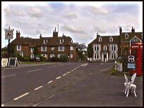
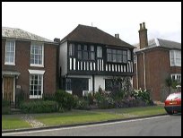 Appledore in Kent village is very pretty, and has an open and peaceful
feel to it.
The walk along the banks of the Royal Military Canal,
is very enjoyable and relaxing, the route to Woodchurch
in the East is owned by the National Trust. Appledore in Kent village is very pretty, and has an open and peaceful
feel to it.
The walk along the banks of the Royal Military Canal,
is very enjoyable and relaxing, the route to Woodchurch
in the East is owned by the National Trust.
The church is pretty and its tapestry and screen are worth a visit. |
|
 Appledore in Kent has a few shops and public houses, but the main
shopping towns are Rye to the West, Tenterden to the North
or Ashford to the East. Appledore in Kent has a few shops and public houses, but the main
shopping towns are Rye to the West, Tenterden to the North
or Ashford to the East.
The nearest train service runs across the Romney Marsh ,
stopping nearby at Appledore station about 1 mile from the
village. |
|
| Appledore is shown as the red symbol on the map. |
|
|
Nearby Villages
(click on symbol to see the village page) |
| Village= | |
Town= | |
Recorded in Domesday= |  |
| |
|
|
Beckley |
(Alfred the Great and Guns !) | | 7.26 miles |
|
|
Bilsington |
(The Priory and Obelisk) | | 6.07 miles |
|
|
Bonnington |
(Saint Rumwold the child saint) | | 7.06 miles |
|
|
Brenzett |
(St Eanswyth a saxon princess) | | 3.27 miles |
|
|
Brookland |
(13th century wooden spire) | | 3.08 miles |
|
|
Fairfield |
(The Isolated Church) | | 1.93 miles |
|
|
Hamstreet and Orlestone |
(The Start of the Ordnance Survey) | | 4.03 miles |
|
|
Iden |
(Sheriff of Kent and Jack Cade) | | 4.28 miles |
|
|
Ivychurch |
(The burial ground on the Island) | | 4.59 miles |
|
|
Kenardington |
(Danes destroy Saxon Fort) | | 2.14 miles |
|
|
Newchurch |
(The Church Tower with a kink) | | 6.33 miles |
|
|
New Romney |
(Cinque Port and Storm) | | 7.38 miles |
|
|
Old Romney |
(Sheep and Wool Smuggling) | | 5.52 miles |
|
|
Peasmarsh |
(Black Death moves village) | | 6.12 miles |
|
|
Ruckinge |
(Smuggling and Traction Engines) | | 4.95 miles |
|
|
Smallhythe |
(The Ellen Terry Museum) | | 3.90 miles |
|
|
Snargate |
(Sluice Gates made by Royal Order) | | 2.34 miles |
|
|
Snave |
(the Remote church) | | 3.56 miles |
|
|
Stone in Oxney |
(Roman stone altar) | | 1.50 miles |
|
|
Tenterden |
(Centre of the Broadcloth industry) | | 5.04 miles |
|
|
Warehorne |
(A good place to explore the Marshes) | | 2.83 miles |
|
|
Wittersham |
(Park your Airship here ?) | | 4.00 miles |
|
|
Woodchurch |
(Dragoons capture Smugglers) | | 2.86 miles |
|
|
| Copyright Villagenet 1998-2025 | |
| |
|
|
Local Interest
Just click an image |
|
|
|
|
|
|
|
|
|
|
|
|
|
|
| |