| |

|
|
|
| |
 Standing on a ridge overlooking the Romney Marsh is the village of
Warehorne in Kent 9 miles east of Tenterden , off the B2067. Standing on a ridge overlooking the Romney Marsh is the village of
Warehorne in Kent 9 miles east of Tenterden , off the B2067.
The village is first mentioned in a charter of the Saxon King Egbert
in 820 AD, where it is called Werehornas. The name has been explained
as 'the place on the bend by the weir'. Presumably on the ancient
course of the river Lymne, the old name for the Rother.
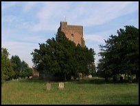
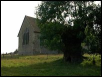
The Domesday book states that there was a church in Warehorne , but
the earliest part of the existing building dates from 1200 AD. The early
English nave was completed by 1450 - 1500 AD.
Warehorne is a good place from which to explore the unusual landscape
of stunted trees, broad dikes, drainage ditches and marshland reedbeds.
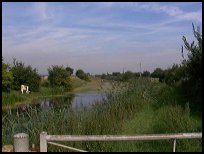
One good way to do this is to follow the Royal Military Canal to
Appledore . This particular stretch of the Canal is Owned by the National
Trust. |
|
 The Saxon Shoreline walk goes through the village, and through the churchyard. The Saxon Shoreline walk goes through the village, and through the churchyard.
The view south west from the churchyard is very pretty.
If you travel down to the Royal Military Canal , there are numerous birds
including swans and many others to see. Fishing in the military canal is
available, but you need to be a member of the local fishing clubs.
A walk down the Military Canal walk is very peaceful, and allows you to
see all sorts of animals and birds in the reeds. |
|
 The village of Warehorne in Kent has small village services. The village of Warehorne in Kent has small village services.
The main large shopping centre is in Ashford with its large number
of shops, and Tenterden for small town shopping.
The nearest trains also run from Ashford , with the main line to London
passing through, together with the Ashford Terminal of Eurostar. |
|
| Warehorne is shown as the red symbol on the map. |
|
|
Nearby Villages
(click on symbol to see the village page) |
| Village= | |
Town= | |
Recorded in Domesday= |  |
| |
|
|
Aldington |
(The Aldington Gang) | | 5.18 miles |
|
|
Appledore |
(Danes invade England) | | 2.83 miles |
|
|
Bilsington |
(The Priory and Obelisk) | | 3.33 miles |
|
|
Bonnington |
(Saint Rumwold the child saint) | | 4.32 miles |
|
|
Brenzett |
(St Eanswyth a saxon princess) | | 3.40 miles |
|
|
Fairfield |
(The Isolated Church) | | 4.07 miles |
|
|
Hamstreet and Orlestone |
(The Start of the Ordnance Survey) | | 1.38 miles |
|
|
Ivychurch |
(The burial ground on the Island) | | 3.82 miles |
|
|
Kenardington |
(Danes destroy Saxon Fort) | | 1.18 miles |
|
|
Newchurch |
(The Church Tower with a kink) | | 4.16 miles |
|
|
Ruckinge |
(Smuggling and Traction Engines) | | 2.24 miles |
|
|
Smallhythe |
(The Ellen Terry Museum) | | 6.24 miles |
|
|
Snargate |
(Sluice Gates made by Royal Order) | | 2.50 miles |
|
|
Snave |
(the Remote church) | | 2.13 miles |
|
|
St Mary in the Marsh |
(Ancient Celts) | | 5.60 miles |
|
|
St Marys Bay |
(Holidays and Beaches) | | 7.03 miles |
|
|
Stone in Oxney |
(Roman stone altar) | | 4.33 miles |
|
|
Tenterden |
(Centre of the Broadcloth industry) | | 6.57 miles |
|
|
Wittersham |
(Park your Airship here ?) | | 6.75 miles |
|
|
Woodchurch |
(Dragoons capture Smugglers) | | 2.91 miles |
|
|
| Copyright Villagenet 1998-2025 | |
| |
|
|
Local Interest
Just click an image |
|
|
|
|
|
|
|
|
|
|
|
|
|
|
| |