| |

|
|
|
| |
 Kenardington in Kent may be found standing on what was once the 'Ancient Saxon'
shoreline, but is nowadays the edge of the Romney Marsh . Kenardington in Kent may be found standing on what was once the 'Ancient Saxon'
shoreline, but is nowadays the edge of the Romney Marsh .
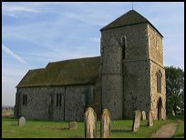
St Marys church stands on the site of what was believed to be a
small Saxon fort. The fort was 600ft long on the eastern side, and
550ft long on the northern side. Unfortunately most of its
earthworks have been ploughed away over the years.
The fort may have been built to repel the Danish invasion, however
it was only half finished when the Danes attacked in 892AD. The Danes
encamped here before moving on to establish themselves at Appledore .
A Saxon church at Kenardington dedicated to St Mary, is recorded
in the Domesday Book. At this time an annual fee of 12d (5p) was
paid to the monks of Christchurch Canterbury. This indicates that
it is likely the monks were the original founders of the church.
The original church may have been wooden, then after the Norman
Conquest of 1066 was replaced by a stone building. The tower dates
from 1170AD and is a square structure without buttresses. To the
north side it has an unusual round tower, which carries the
staircase to the belfrey at the top of the main tower.
The church is another one a long way away from the village, which
implies quarantine at the time of the Black Death .
In the 14th century, it is believed that the church was sacked
by the French during the Hundred Years War , but there is no
remaining evidence. In 1559 the church was struck by lightning,
and which started a fire causing the collapse of the nave, chancel
and the north aisle. |
|
 If you travel up to the church, and walk round the churchyard,
the area is very deserted, and you can imagine the Danes attacking
the Saxons in the fort nearby. If you travel up to the church, and walk round the churchyard,
the area is very deserted, and you can imagine the Danes attacking
the Saxons in the fort nearby.
Also from the church, the valley to the north east would have been flooded
by the sea in Saxon times, although now it is many miles inland. |
|
 Kenardington in Kent is a very small village with very limited services, the nearest
shops are in Hamstreet . Kenardington in Kent is a very small village with very limited services, the nearest
shops are in Hamstreet .
The main large shopping centre is in Ashford with its large number
of shops, and Tenterden for small town shopping.
The nearest trains also run from Ashford , with the main line to London
passing through, together with the Ashford Terminal of Eurostar. |
|
| Kenardington is shown as the red symbol on the map. |
|
|
Nearby Villages
(click on symbol to see the village page) |
| Village= | |
Town= | |
Recorded in Domesday= |  |
| |
|
|
Aldington |
(The Aldington Gang) | | 6.21 miles |
|
|
Appledore |
(Danes invade England) | | 2.14 miles |
|
|
Bilsington |
(The Priory and Obelisk) | | 4.42 miles |
|
|
Bonnington |
(Saint Rumwold the child saint) | | 5.41 miles |
|
|
Brenzett |
(St Eanswyth a saxon princess) | | 3.91 miles |
|
|
Fairfield |
(The Isolated Church) | | 3.82 miles |
|
|
Hamstreet and Orlestone |
(The Start of the Ordnance Survey) | | 1.97 miles |
|
|
Ivychurch |
(The burial ground on the Island) | | 4.66 miles |
|
|
Newchurch |
(The Church Tower with a kink) | | 5.33 miles |
|
|
Ruckinge |
(Smuggling and Traction Engines) | | 3.38 miles |
|
|
Smallhythe |
(The Ellen Terry Museum) | | 5.12 miles |
|
|
Snargate |
(Sluice Gates made by Royal Order) | | 2.87 miles |
|
|
Snave |
(the Remote church) | | 3.08 miles |
|
|
St Mary in the Marsh |
(Ancient Celts) | | 6.66 miles |
|
|
Stone in Oxney |
(Roman stone altar) | | 3.61 miles |
|
|
Tenterden |
(Centre of the Broadcloth industry) | | 5.40 miles |
|
|
Warehorne |
(A good place to explore the Marshes) | | 1.18 miles |
|
|
Wittersham |
(Park your Airship here ?) | | 5.81 miles |
|
|
Woodchurch |
(Dragoons capture Smugglers) | | 1.80 miles |
|
|
| Copyright Villagenet 1998-2025 | |
| |
|
|
Local Interest
Just click an image |
|
|
|
|
|
|
|
|
|
|
|
|
|
|
| |